News
Greetings from Wageningen
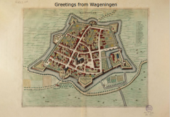
To welcome the new students to Wageningen University, Special Collections had a postcard made of a Wageningen city map from 1698. The card was distributed at several locations during the Annual Introduction Days (AID). What's the story behind this Wageningen map? Who made and published it?
Greetings from Wageningen
For the AID 2021, we had a postcard made with a historical drawing of a Wageningen city map. You can find the online version of the map from c. 1698 and other historical maps in the Image Collection Old Maps and Atlases.

Wageningen City Map
The Wageningen city map was published by Frederick de Wit in c. 1698. Frederick de Wit was a copper engraver, publisher and seller of maps and atlases in de Kalverstraat in Amsterdam. The Special Collections department of Wageningen University & Research bought one of the original prints almost three hundred years after it was printed, in August 1996.
The first edition of this map was drawn by Nicolaes van Geelkercken in 1640. He was a land surveyor and carthographer in Gelre (Gelderland). Frederick de Wit updated the map 50 years later in 1698.
The map of Wageningen held by Special Collections is most likely a rare proof for the first edition of De Wit's City Atlas. The copper plate that was used to produce this map is clearly unfinished, which can be concluded from the empty corners of the map. In later editions, the coats of arms of Wageningen city and the Province of Gelderland were printed in the upper corners.
De Wit's City Atlas
Frederick de Wit bought copper plates from famous map makers, like Blaeu and Jansonius, at auctions. With these and copper plates from others, like Nicolaes van Geelkercken, he published a city atlas with 124 city maps that could be bought in his book shop 'In den Witte Pascaert'.
The City Atlas contained maps of important cities in the 'Lage Landen' (Low Countries) in the 17th century. Amersfoort, Doesburgh and Wageningen were three of these cities.
The Koninklijke Bibliotheek owns one the five known copies of the De Wit's City Atlas. You can find a printed facsimile of the City Atlas in the Forum Library. A facsimile is a faithful, exact reproduction of a manuscript or book, with its original colours and irregularities.
Map collection
Special Collections holds a large collection of maps and atlases. A small part, old and mostly hand-coloured topographical maps, is available digitally. The oldest maps date from c. 1570, the newest from c. 1860. The maps from the WUR Image Collections can be downloaded for free. Please be sure to check the Copyrights and licenses page if you want to use an illustration in a publication.
References
1. De jonge Nicolaes van Geelkercken. Caert-Thresoor, 20(2001) 2, p. 41-47.
2. Stedenatlas De Wit. Website Koninklijke Bibliotheek (visited 10 August 2021)
3. Liesbeth Missel, Stadsplattegrond van Wageningen (internal notes).