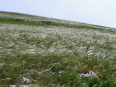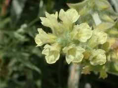
Murgia Alta and Valloni
Case study area SCI Murgia Alta IT9120007 – Puglia (1258,89 km2)
The most important habitat types in this site, according to 42/93/EEC directive are, 6210(*)Semi-natural dry grasslands and scrubland facies on calcareous substrates (Festuco-Brometalia) (*important orchid sites) and 6220* Pseudo-steppe with grasses and annuals of the Thero-Brachypodietea.
The regional Autority, in charge for compliance to the Habiat Directive is most concerned of the degradation of the habitat (loss, fragmentation, quality depletion) particularly in connection to the conservation of Falco biarmicus feldeggi and Falco naumanii, (globally threatened and priority species according to the Birds Directive). These species are present in the reproductive phonological phase. About ten years were elapsed in the boundaries definition of the SCI Murgia Alta IT9120007, located in a hill area of Regione Puglia and to formalize its inclusion in Natura 2000 network.

In such a time span the area, which is characterized by the presence of unique highly diverse ecosystems and also of endemic and threatened species, was exposed to a tremendously accelerated process of habitat fragmentation and contamination both within and at its borders by a number of combined pressures. Among these: the Common Agricultural Policy (CAP) drove transformation of grassland pastures into agricultural (cereal crops) areas, which also induced soil erosion and sediment deposition in aquifer, contamination; the illegal waste and toxic mud dumping on transformed areas causing heavy metal contamination of soils and aquifer system; the increasing of traditional legal and illigal mining activities; wind farms infrastructures.

On this SCI Murgia Alta IT9120007 N2000 site it is available a 1:50.000 map of natural environments (Carta della Natura) compiled by the Agenzia Regionale per la Protezione Ambientale (ARPA) by means of visual ortophoto interpretation (2005) as well as of processing a multi-seasonal Landsat TM image series (three 2006 images), and validated by local inspection by the National Istituto Superiore per la Protezione e la Ricerca Ambientale (ISPRA), which provided funds for the project. However, due to its relatively coarse resolution the map is already in the process of being updated and downscaled to 1:25.000.
Moreover, the Regional Management Authority (Ufficio Parchi) which is involved in VIA and planning procedures is interested in far more detailed habitat maps both back in time and apt to be promptly updated in order to evaluate the kinds and degrees of changes occurred in distribution and state of biodiversity in that SCI.
Case study area SPA-SCI Valloni e steppe pedegarganiche IT9110008 (312,02 km2)

This case study area is located in the Northeastern part of the region Puglia. It includes 6220* Pseudo-steppe with grasses and annuals of the Thero-Brachypodietea and also supports Falco biarmicus feldeggi and Falco naumanii nesting during reproduction. This site is subject to heavy human pressures, such as fragmentation due to the transformation of habitat type grassland pasture into agricultural (cereal crops), industrial and transport infrastructure.