
Colloquium
Combining Sentinel-1 and Landsat NDVI Time Series for abrupt disturbance detection on Fiji’s mangrove forests
By Jan Pokorn (Slovenia)
Abstract
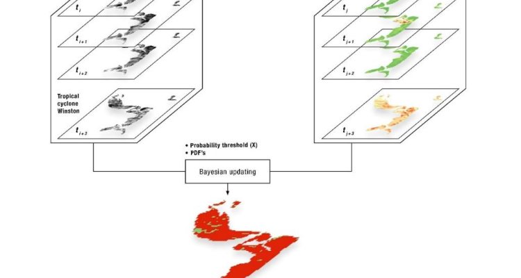
Mangrove ecosystems play a crucial role in the protection of coastal areas in Fiji. In addition, they are considered to be one of the largest carbon sequesters in (sub) tropical areas, playing an important role in the global carbon cycle. Therefore, conservation efforts are directed towards developing a reliable monitoring system with the capacity to detect disturbances in near real time. With the use of new medium-resolution sensors, dense time series became available for analysis, enabling timely and accurate disturbance detection. The potential of combining synthetic aperture radar (SAR) and optical datasets into dense time series for decreasing detection delays has already been proven. Here, we combined multi-temporal Sentinel-1 C-band SAR with Landsat NDVI for near real time disturbance detection after the tropical cyclone Winston. We used spatial normalization for Landsat and combined it with Sentinel-1 within a probabilistic approach. We compared the obtained results to using Landsat and Sentinel-1 separately. Our findings show that, in comparison to Landsat, using Sentinel-1 significantly decreases the disturbance detection delay due to a high observation density and a high proportion of valid observations per acquisition. In the area we used for the methodology development, using combined datasets resulted in further improvement of the temporal and spatial accuracy. We developed a thorough validation approach and created our own reliable reference dataset to compensate for the lack of field reference data. In addition, we calculated accuracy measures for different confidence levels to demonstrate the possible trade-off scenarios between the spatial and temporal accuracies depending on the user’s objective. User’s and producer’s accuracies of the combined dataset at the highest confidence level of confirmed disturbance were 96% 89% respectively. The disturbance detection time delay was 24 days. In comparison, the disturbance detection delay when using only Sentinel-1 was 26 days, and 71 days when using only Landsat. We decided to extrapolate our methodology to an area with a larger extent (Eastern part of Viti Levu) and estimate the damage caused by the Winston tropical cyclone. Our results show that 37% of mangrove ecosystems in the study area experienced disturbance and the time delay of confirmed disturbance was 48 days. We recommend adaptations to our existing methodology for further research.
Keywords: Sentinel-1; Mangroves; Landsat; Near real time; Change detection; Forest disturbance; Tropical cyclone; Time series