
Thesis subject
MSc thesis topic: EO for monitoring the sand mining crisis in the Vietnamese Mekong Delta
The global demand for sand has been rapidly increasing over the past few decades leading to unsustainable acceleration of sand abstraction. The Vietnamese Mekong Delta (VMD), in particular, has been heavily affected by excessive sand mining, and as a result is experiencing a range of socio environmental impacts including loss of land and damage to infrastructure and livelihoods from accelerated rates of bank erosion. The aim of this project would be to develop Earth Observation (EO) tools to aid monitoring sand mining activity and its impacts.
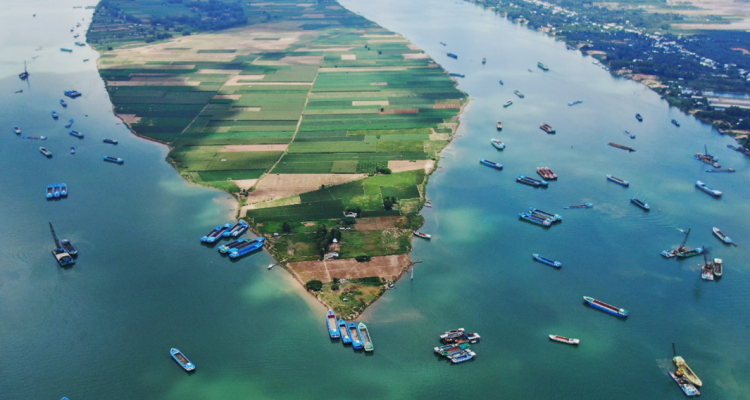
In the VMD, sand is extracted from the river bottom using crane barges and is often subsequently deposited on the riverbank prior to being shipped to the final destination. Unregulated mining, in particular, poses a tangible threat, and whilst local communities in Vietnam are actively reporting it, more effective monitoring is needed to regulate mining activity at basin scale and better understand its impacts. Satellite remote sensing presents great opportunities for creation of tools that can help evaluate mining intensity, track riverbank erosion and characterise distribution networks, complementing current monitoring approaches.
The exact topic of the project will be chosen with the supervisor. Potential focus area can include (but is not restricted to):
- Developing a workflow for riverine vessel detection and extraction of vessel size from PlanetScope imagery.
- Mapping river extent to capture riverbank erosion over time. There is potential to explore different methods, different satellite systems (Sentinel-1, Sentinel-2, LandSAT, PlanetScope) and multi-sensor analysis approaches.
- Mapping changing water turbidity levels or suspended sediment load and analysing their relationship with available river traffic density dataset.
Objectives
- Literature review and methodology design
- Accuracy assessment of the developed approach
- Generation and analysis of the multi-temporal product
Literature
- Bendixen, M., et al. “Time is running out for sand.” (2019): 29-31.
- Illegal Sand Mining Is Ruining These Countries' Ecosystems
- Sekar, N. A., et al. “A DPSIR Assessment on Ecosystem Services Challenges in the Mekong Delta, Vietnam: Coping with the Impacts of Sand Mining.” Sustainability 12 (2020): 9323.
- Huang, C., et al. “Detecting, Extracting, and Monitoring Surface Water From Space Using Optical Sensors: A Review.” Reviews of Geophysics 56 (2018): 333-360.
- Gruel, C. R., et al. “New systematically measured sand mining budget for the Mekong Delta reveals rising trends and significant volume underestimations.” International Journal of Applied Earth Observation and Geoinformation, 108 (2022), 102736.
- Smigaj, M., et al. “Monitoring riverine traffic from space: the untapped potential of remote sensing for measuring human footprint on inland waterways.” Sci. Total Environ., 860 (2023), 160363.
- Dang, T. D., et al. “Quantifying suspended sediment dynamics in mega deltas using remote sensing data: A case study of the Mekong floodplains.” International Journal of Applied Earth Observation and Geoinformation, 68 (2018), 105-115.
- Deng, Z., et al. “Learning Deep Ship Detector in SAR Images From Scratch.” IEEE Transactions on Geoscience and Remote Sensing 57 (2019): 4021-4039.
Requirements
- Experience in using satellite remote sensing data
- Good knowledge in scripting is a preference (e.g. R, Python, Google Earth Engine)
Theme(s): Sensing & measuring; Integrated Land Monitoring