Impact story
Nature-based solutions for urban climate adaptation
Cities are hubs for economic activity, social-life, culture and technological innovation. Climate change will affect these hubs, through extreme events, such as heavy rains, high water-levels, heatwaves and droughts. Climate adaptation strategies have been designed to cope with the effects of these events, including erosion, water shortage and breaches in dykes.
Motivation
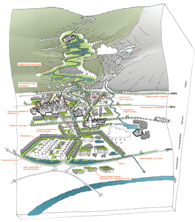
The rural communities east of Arnhem (the Netherlands) are located on the edge of a complex of terminal push moraines that have been formed by Saalian glaciation. The area has a pronounced relief according to Dutch standards, with the highest point at over 100 metres above sea-level and a steep gradient down to a river floodplain. The communities expect a continued increase in forest fires, river floods, risk for dyke breaches, insufficient sewerage capacity to cope with heavy rains, erosion, risk for traffic safety due to storms, and seepage due to increased pressure from the growing groundwater stock uphill. What measures can be taken to counteract these impacts and where should they be implemented?
Solution
An environmental vulnerability map was created based upon landscape characteristics such as soil, 'green-space'- and and road infrastructure and topography. This map provided the basis for the localisation of adaptation measures such as water storage basins and swamp development, zones for increasing the variety of tree species and excavating wadis (ravines or river gullies). The maps are accompanied by practical, but general visions for climate adaptation, such as: more greenery and less pavement in industrial zones.
Wageningen University & Research carried out these activities in cooperation with: municipality of Rheden, GrondRR, waterboard Vallei en Veluwe, waterboard Rijn en IJssel and Climate Connects.
This information and these ideas are substantive building blocks for the spatial adaptation programme
Impact and future perspective
The present spatial adaptation plans and visions provide insight into the effects of the expected climate changes within the municipalities to the East of Arnhem. These suggestions provide an approach at this stage that must be elaborated over the coming years.
