News
Transmitter masts predict rain
Rain showers are difficult to predict, as they usually develop into a downpour within half an hour, resulting in flooding. Much depends on being able to spot time, location and precipitation ahead of time on the radar. The well-known precipitation radar now gets unexpected help. Researchers from WUR, KNMI (Dutch national meteorological institute) and Deltares use the signal strength of commercial transmitter masts for cell service to precisely measure the precipitation between two points, but also to develop a forecast for several hours.
Mobile phone traffic
Ruben Imhoff of the Wageningen Hydrology and Quantitative Water Management Group collaborated with colleagues from KNMI and Deltares to discover how they might deduce the intensity of rainfall between two masts based on the commercial microwave links (CMLs) between the towers. These CMLs are the radio wave signals used by mobile phone traffic.
‘Communication companies are interested in as clear a signal as possible. But we are considering the precise opposite’, says Ruben Imhoff. The attenuation of the signal may be caused by the intensity of the rainfall between two masts. ‘The more intense the precipitation, the more scrambled our data is bounced back. We map these disruptions and translate them into the intensity of precipitation, as well as into short-term forecasts, also known as “nowcasting”.’
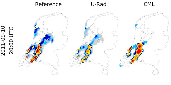
The research team compared data from the KNMI precipitation radars (as used by the Buienradar app and website) with the data obtained from phone companies’ towers on twelve rainy days. ‘The results pleasantly surprised us’, says Imhoff. ‘The CML method proves to work fairly well, even during heavy rainfall.’ Occasionally, the rain forecast was better than the radar forecast, especially during heavy showers. ‘However, you must take into consideration that the radar products were not corrected for deviations. Radars too can be improved, and this is currently underway.’

Predicting localised rainfall
The question is, whether CML provides an alternative to radar, which gives a precise overview per square kilometre, including over bodies of water. ‘Radar provides a stable overview of a large area. Radio wave signals are dense, spaced approximately half a kilometre apart in urban centres, but less so in rural areas. Moreover, the precipitation radar refreshes every five minutes, while the CML data is recorded fifteen minutes apart. Increasing the frequency to every five minutes could improve the data. CMLs are a valuable addition to radar data in the Netherlands. These combined images may be used for nowcasting, for example, to predict localised showers.’
5G-towers
This is also the case for 5G towers. These are even more densely spaced, and, as such, provide more accurate data. However, the researchers don’t yet know how this will work out, as it is yet unclear how well the CML system works with the higher transmission frequencies employed by 5G. A research proposal for this issue is pending.
The CML-system may prove to be particularly useful in countries lacking precipitation radars but with transmitter towers in the urban areas. The KNMI and WUR intend to investigate whether this method may provide short-term forecasts in Nigeria and Sri Lanka.