
Project
Developing a high-resolution 4-dimensional soil modelling and mapping platform for the Netherlands (BIS-4D)
Smart and sustainable land and water management is crucial to secure the well-being of future generations, especially in highly populated areas like the Netherlands, where many different functions are combined in a small area. Decision makers therefore require accurate and up-to-date soil information at a high resolution. To meet these demands, we are developing a spatio-temporal soil modelling and mapping platform for the Netherlands called "Bodemkundig Informatie Systeem 4D" (BIS-4D). The objectives of this project are to prioritize soil information according to user requirements, develop and apply a data-driven, 3D modelling strategy of soil properties and harmonize outdated soil data to a common age. Ultimately, we aim to provide information of key soil properties at any location, depth and time for every 25 m pixel in the Netherlands. In this way, we can ensure that BIS-4D is useful for regional, national, European and global initiatives contributing to the sustainable use and protection of soils.
- Unfortunately, your cookie settings do not allow videos to be displayed. - check your settings
![Soil pH [KCl] predictions (mean) for every 25 m pixel over the entire Netherlands for the six depth layers specified by GlobalSoilMap](/upload_mm/e/c/c/4fc5f97a-5d24-4b22-b1ee-f5a010c088e8_Anatol_m_pH_KCl_pred_mean_all_depths_e7d96de0_670x537.jpg "Soil pH [KCl] predictions (mean) for every 25 m pixel over the entire Netherlands for the six depth layers specified by GlobalSoilMap")
Soil pH [KCl] predictions (mean) for every 25 m pixel over the entire Netherlands for the six depth layers specified by GlobalSoilMap (Helfenstein et al., 2022)
![5th(left), 50th (middle) and 95th quantile (right) pH [KCl] predictions for every 25 m pixel over the entire Netherlands for the depth layer 15 cm to 30 cm.](/upload_mm/5/0/0/b8e07217-f367-4f06-9c15-5de0614bbf7a_m_pH_KCl_d_15_30_pred_1118b041_670x283.jpg "5th(left), 50th (middle) and 95th quantile (right) pH [KCl] predictions for every 25 m pixel over the entire Netherlands for the depth layer 15 cm to 30 cm.")
5th(left), 50th (middle) and 95th quantile (right) pH [KCl] predictions for every 25 m pixel over the entire Netherlands for the depth layer 15 cm to 30 cm (Helfenstein et al., 2022)
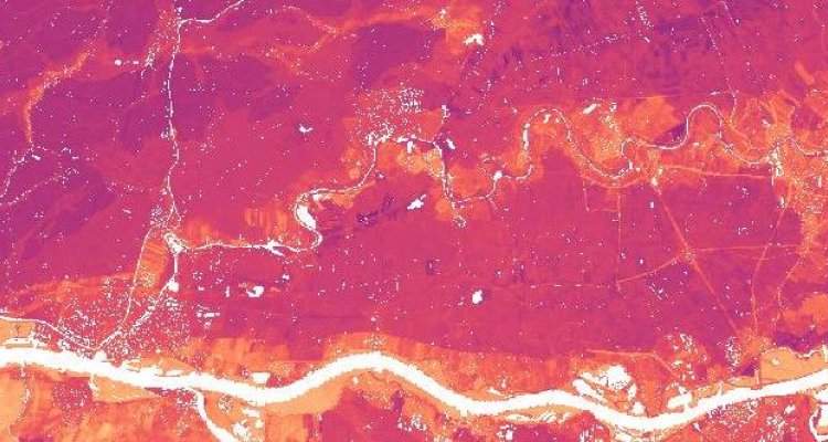
![Zoom in of soil pH [KCl] for the depth layer 15 cm to 30 cm and the related accuracy thresholds, by means of which we specify map quality for end-users.](/upload_mm/1/a/b/deb3897a-42e0-47d7-a5c8-2ea0845a220f_anatol_phKCl_15_30_21873e53_670x473.jpeg "Zoom in of soil pH [KCl] for the depth layer 15 cm to 30 cm and the related accuracy thresholds, by means of which we specify map quality for end-users.")
Zoom in of soil pH [KCl] for the depth layer 15 cm to 30 cm and the related accuracy thresholds, by means of which we specify map quality for end-users (Helfenstein et al., 2022)