Project
Characterizing and predicting forest disturbance with satellite data and artificial intelligence
Current technological developments in satellite imaging and artificial intelligence hold an unprecedented potential for better forest monitoring from space. This PhD project aims to employ these developments for advancing near real-time forest monitoring methods, focusing on the rapid characterization and prediction of forest disturbances.
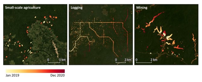
Satellite-based forest monitoring is key for detecting forest degradation and deforestation, with near real-time alert systems being a primary tool for forest management and law enforcement against illegal activities. However, mapping the location of new forest disturbances only does not always suffice for timely and targeted intervention on the ground. Additional near real-time information on the driver or type of a new disturbance and predictions of where future disturbances will likely happen are among the major needs of stakeholders in tropical regions. This PhD project addresses these needs, by developing methods for rapid characterization and prediction of small-scale forest disturbance, using multi-sensor satellite data in combination with artificial intelligence.
This study has a strong focus on the rapidly expanding logging activities in the tropical forests of the Congo Basin. High spatiotemporal resolution Sentinel-1 radar data is used as a primary data source for characterizations and predictions, complemented with Sentinel-2 and Planet imagery. For further assessments of forest logging activities, aboveground biomass data and ground-truth reference data are used. Expected results include near real-time methods to characterize different types of forest disturbance and their ecological impacts, and methods to identify high-risk areas for near-future logging. Three main research objectives are addressed.
1. Characterizing small-scale forest disturbances in near real-time.
This study is aimed at near real-time methods to classify detected forest disturbances into several categories (e.g. smallholder agriculture, selective logging, mining). Sentinel-1 radar data is used to detect forest disturbances, and further classification is done with deep learning techniques and multi-sensor satellite data.
2. Assessing logging activities and their ecological impacts.
This study is aimed at methods to further characterize logging activities specifically. There is a focus on analyzing different types and patterns of logging activities and assessing their ecological impacts. Biomass loss, harvest intensities, forest recovery and forest fragmentation are quantified in areas undergoing logging, using multi-sensor satellite data, ground-truth data and aboveground biomass datasets.
3. Predicting near-future logging activities.
This study is aimed at methods to predict the spatiotemporal patterns and impacts of near-future logging activities. Deep learning methods are employed to develop a predictive self-learning model, using historical detections of logging patterns, time series of multi-sensor satellite data and additional geospatial datasets.
