Greece test sites
The Greek Natura 2000 sites (test sites) are:
EKVOLES KALAMA (Kalamas Delta) (GR2120001)
ELOS KALODIKI (Kalodiki Fen) (GR2120002)
STENA KALAMA (Kalamas Gorge) (GR2120004)
All three sites are located in the prefecture of Thesprotia in the administrative region of Epirus (NW Greece) (Figs. 1a, b).

Kalamas River delta
Site GR2120001 is the Kalamas River delta covering an area of 8481 ha. The riparian forest stands play an important ecological role and are characterized by high historic and aesthetic value. The surrounding hills affect the structure and function of the Kalamas wetland, while the reed and tamarisk thickets and halophytic plant communities are typical of river estuaries with high phytodiversity.
The aquatic vegetation of the site is composed of plant communities assigned to the classes: Lemnetea minoris, Ceratophylletea demersi and Potamogetonetea pectinati. The reed thickets present high diversity and belong to the class Phragmitetea with dominant species Phragmites australis. The zonal development of halophytic communities and wet meadows with Juncus sp. is very characteristic (Fig. 2).

Kalodiki Fen
The location of Kalodiki Fen (Site GR2120002) is shown in Figs. 1a and 1b. The site has coordinates of 20o26'46''E to 20o28'14''E and 39o19'20''N to 39o17'53''N. Kalodiki wetland consists of two lakes (one large and one small) embedded in a topogenous mire or fen, located in a small basin created by a tectonic depression. The fen consists of two proximate peatlands which occupy an area of 195 ha, surrounded by hills of 550 m altitude. The whole Kalodiki wetland, as an SCI (Site of Community Importance), covers an area of 845 ha. Kalodiki Fen is an inland, freshwater wetland belonging to the western chain of Greek wetlands.
Eighteen vegetation types, of which nine are ranked as associations and nine as frame communities, have been recorded here. They belong to the Phragmition communis, Magnocaricion elatae, Nymphaeion albae, arvopotamion, Ranunculion aquatilis, Lolio-Potentillion anserinae, Nerion oleandri, and Bidention tripartitae. Kalodiki is a relatively heterogeneous wetland with small-scale variation. Its vegetation is characterised by a mosaic of well-developed swamp, mesotrophic and eutrophic freshwater, aquatic plant communities, in various combinations of spatial arrangement. The diversity of the wetland vegetation habitats, based on the number of syntaxonomic units recognized within the major vegetation types, decreases in the following order: swamp and fen vegetation dominated by graminoids, sedges and forbs (8) communities of rooted, floating or submerged macrophytes in mesotrophic and eutrophic fresh waters (6) low herb communities of various habitats with wet-dry, or brackish-fresh conditions (2) communities of enriched margins of still or sluggish waters and damp disturbed places (1) tamarisk woodlands on soils inundated with fresh water (1).

The ecological state of the whole ecosystem is strongly dependant on a small dam. Farmers frequently damage the dam in order to irrigate their crops. The dam is badly maintained and often leaks. Eutrophication observed in the site is caused by erosion, agricultural activities and pollution. The wetland ecosystem is often disturbed by illegal activities such as hunting, rubbish dumping, and illegal cultivations within the wetland.

Kalamas Gorge
Site GR2120004 Stena Kalama (Kalamas Gorge) has a surface area of 1867 ha (Figs. 1a, b). The vegetation of the slopes of Kalamas Gorge has good conservation status. The deciduous woodland found in this site consists of various tree species and the composition of the maquis vegetation is representative of this habitat type at these altitudes (c. 450m a.s.l.). The gorge’s slopes are densely covered with mixed broadleaved deciduous and sclerophyllous vegetation with Carpinus orientalis, Fraxinus ornus, Ulmus campestris Pistatus lentiscus, Quercus pubescens, Q. coccifera, Q. ilex, Phillyrea latifolia. The riparian forest with Platanus orientalis, Salix alba, S. cinerea & Alnus glutinosa occupies a zone of 10-30 m width. Finally, stands of Scirpus holoschoenus and Carex sp. grow along the river near the water.
Habitat types and distribution in the test sites
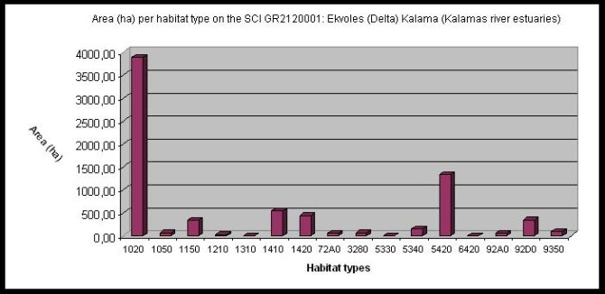
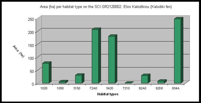
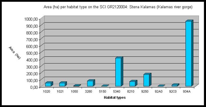
Table 1 summarizes the habitat types present in each test site.| Habitat type | Habitat code | GR2120001 | GR2120004 | GR2120002 |
|---|---|---|---|---|
| Estuaries | 1130 | * | ||
| Coastal lagoons | 1150 | * | ||
| Annual vegetation of drift lines | 1210 | * | ||
| Salicornia and other annuals colonizing mud and sand | 1310 | * | ||
| Mediterranean salt meadows (Juncetalia maritimi) | 1410 | * | ||
| Mediterranean and thermo-Atlantic halophilous scrubs (Arthrocnemetalia fruticosae) | 1420 | * | ||
| Embryonic shifting dunes | 2110 | * | ||
| Natural eutrophic lakes with Magnopotamion or Hydrocharition - type vegetation | 3150 | * | ||
| Constantly flowing Mediterranean rivers with Paspalo - Agrostidion species and hanging curtains of Salix and Populus alba | 3280 | * | * | |
| Thermo-Mediterranean and pre-desert scrub Euphorbia dendroides | 5330 | * | ||
| Sarcopoterium spinosum phryganas | 5420 | * | * | |
| Mediterranean tall humid grasslands of the Molinio-Holoschoenion | 6420 | |||
| Calcareous fens with Cladium mariscus and Carex davalliana | 7210* | * | ||
| Calcareous rocky slopes with chasmophytic vegetation Campanulion versicoloris | 8210 | * | ||
| Quercus trojana woods | 9250 | * | ||
| Salix alba and Populus alba galleries | 92AO | * | * | |
| Platanus orientalis and Liquidambar orientalis woods (Platanion orientalis) | 92CO | * | ||
| Southern riparian galleries and thickets (Nerio-Tamaricetea and Securinegion tinctoriae) | 92DO | * | * | |
| Quercus macrolepis forests | 9350 | * |
| Habitat type | Habitat code | GR2120001 | GR2120004 | GR2120002 |
|---|---|---|---|---|
| Pteridium aquilinum stands | 5150 | |||
| Garrigues of Eastern Mediterranean | 5340 | * | ||
| Reed thickets (Phragmites australis) | 72A0 | * | * | |
| Greek Quercus coccifera woods | 934A | * | * | |
| Cultivated land | 1020 | * | * | * |
| Anthropogenic vegetation | 1021 | * | ||
| Settlements | 1050 | * | * | * |