A working landscape for New Orleans
It has been well over 4 years since hurricane Katrina struck the South Louisiana coastline near New Orleans, flooding 80% of the city up to 9’ (3m) (Campanella, 2008), and forcing virtually all citizens to evacuate. Substantial investments in flood mitigation infrastructure will ensure a greater safety from hurricane threats by 2011. However this does little to improve the day to day quality of the living environment for the residents of New Orleans.
Competition: Scriptieprijsvraag Land en Water 2011 - First Prize
Competition: International Water Week 2011 - Best Young Scientist Paper
Competition: IFLA 2010 - Jury Award (jury report - pdf 117kb)
Supervisors: Ir. R. van Etteger, Dr.Ir. I. Duchhart, Ir. M. van Stiphout (DS Landscape Architects)
Report (pdf 90mb)
Summary (pdf 91kb)
Posters (pdf 38mb)
Summary
It has been well over 4 years since hurricane Katrina struck the South Louisiana coastline near New Orleans, flooding 80% of the city up to 9’ (3m) (Campanella, 2008), and forcing virtually all citizens to evacuate. Substantial investments in flood mitigation infrastructure will ensure a greater safety from hurricane threats by 2011. However this does little to improve the day to day quality of the living environment for the residents of New Orleans.
The historical parts of the city, located on higher grounds, do well. Population is reaching close to pre‐Katrina levels here and the same buzzing, festive and easygoing atmosphere is again living up the streets. However elsewhere, large parts of low‐lying suburbs are by all means still severely damaged. Today, 20% of the New Orleanians have not returned (Times‐Picayune, 2009) and it is questionable whether they ever will. The Gentilly and Lakeview neighborhoods are typical examples of such low‐lying suburbs and form the focus area of this study.
New Orleans is not just threatened by occurrences like hurricanes. This research focuses on rainflood events, subsidence, the permanent consequence of vegetation loss, vacancy, and the resulting changes in atmosphere of the neighborhoods. Together they determine the landscape quality. We conclude that this landscape quality is below average, will not recover on the basis of existing policies and form ‘new normal’ conditions in Lakeview and Gentilly.
Being landscape architects we have tried to tackle three main problems in these areas:
- The research has shown the precise problems with extreme amounts of rain that regularly occur in this area. Extreme rain events frustrate the broken storm
water system causing interior flood problems up to 2’ (60cm) during a 1/ 10 year storm event (BCG Engineering, 2003). - There is a detrimental effect on the vegetation of Hurricane Katrina. Both the strong winds and the brackish flood waters of Katrina destroyed 70% of
the urban canopy, an estimated total amount of 100.000 trees (Ierardi, 2008; HikeforkaTREEna, 2009). This results in a lack of shade during hot summers and
a barren and deserted looking suburban landscape. - The consequences of abandonment of homes is researched and visualized. Over 30% of the residential plots in Lakeview and Gentilly are currently
unoccupied (GNOCDC, 2009), causing a perforated urban tissue. This perforated tissue will not heal on its own accord and needs a structural rethinking, but it
also offers opportunities for changes in watermanagement.

After 4 years of ‘laissez‐faire’ politics (a strategy focused on short‐term recovery), the Dutch Dialogues Workshops and the Draft Master Plan for New Orleans 2030 now make, among other initiatives, serious attempts to address structural problems. Problems that can only be unraveled with integrated, long term strategies.
This thesis proposes a transformation process aimed at a working landscape. This working landscape performs for humans by ensuring a healthy and pleasant living environment, through inclusion of ecological processes. And this working landscape informs humans by inspiring, revealing and triggering the imagination.
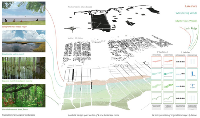
Four landscape zones are revealed that refer to the original landscapes and provide basic concepts for interventions on all scale levels, addressing the 3 problems stated above. Part of this transformation is a new strategy regarding water management, advocating a connected water system based on store‐retain‐discharge principles. As such it mitigates rain flood events, offers conditions for native, sustainable vegetation and provides attractive
public space. The huge amount of space left vacant after hurricane Katrina is considered both a necessity and a chance to implement extensive water and robust structures of native and storm proof vegetation in the Lakeview and Gentilly Neighborhoods. A working landscape in this way may turn these lowlying areas into attractive and distinctive suburbs that New Orleans and its inhabitants so rightly deserve.
New Orleans’ large City Park—covering more acres than New York’s Central Park—located in the centre of the study area will function as an anchor point and showcase for the new landscape structure in the neighborhoods. The park is redesigned as a water machine that can store 30.105.753 cf. (852.500 m3) of water during rain events, 26% of the storage assignment. Also the park clearly demonstrates how an interpretation of the former appearance of the landscape can provide a connection with place and nature, and enrich the character and identity of the city.
Three studies show how this landscape looks in the urban context and answer questions on smaller scale levels regarding the strategic allocation of vacant space—voids, plots and medians varying in size—for the working landscape structure, and show how canals, grass lined swales and retention ponds can be developed in order to not only function well but also look good; truly water as an amenity for the great city of New Orleans.