Project
Model-based Bayesian geostatistics for multi-scale mapping of soil and agronomic variables
PhD project Luc Steinbuch on geostatistics
Problem definition and objective
Geostatistics aims at optimal spatial interpolation of environmental variables from the available information. The most important source of information are direct point observations of the variable of interest, but other valuable information sources are spatially exhaustive covariates (e.g. remote sensing imagery), legacy data sets (e.g. data and maps harvested from library searches), and outputs of mechanistic process models (e.g. crop yield models). The challenge is to use each information source optimally by taking the accuracy of each information source and their strength of relationship with the target variable into account.
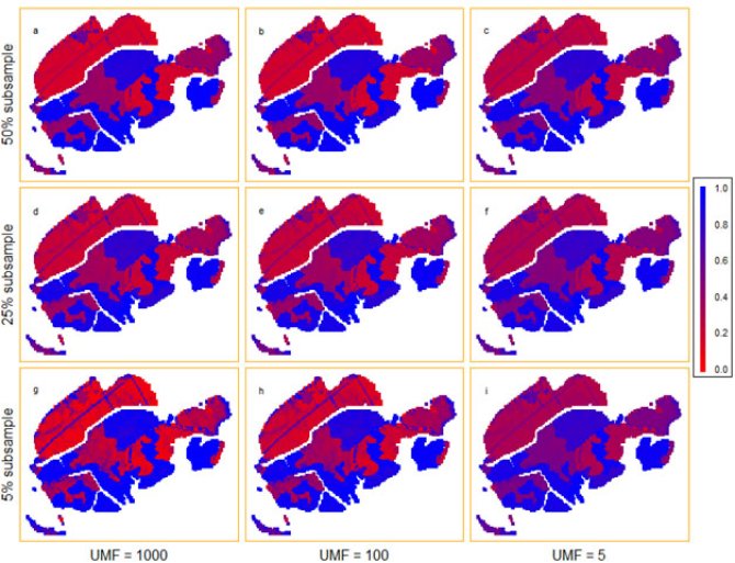
Figure 1: Example of spatial estimation of the probability on ripened clay soils in a small area close to the city of Zoetermeer, Netherlands. Combining different information sources (different sizes for observations, rows vs. different trust in legacy data, columns) yields different maps. From: Steinbuch et al., 2018.
Methodology
In this project we address this problem using a model-based Bayesian geostatistical approach. Bayesian geostatistics is attractive because it completely captures the uncertainty in spatial predictions by taking several uncertainties into account, and can combine different information sources in a methodologically sound way. With this project, we will bridge this gap by developing Bayesian approaches specifically aimed at solving soil and agronomic challenges. We will demonstrate the added value of these approaches by considering case studies from digital soil mapping and agronomic-variables such as agronomic crop yield gap mapping. It is hypothesized that the novel methods produce maps that are more accurate than those obtained with existing methods and provide more realistic quantifications of uncertainty about the maps.
Publications and presentations (status February 2021)
Published papers and datasets
- Luc Steinbuch, Dick J. Brus, Lenny G.J. van Bussel, Gerard B.M. Heuvelink, Geostatistical interpolation and aggregation of crop growth model outputs, European Journal of Agronomy, Volume 77, July 2016, Pages 111-121, https://doi.org/10.1016/j.eja.2016.03.007.
- Luc Steinbuch, Dick J. Brus, Gerard B.M. Heuvelink, Mapping the probability of ripened subsoils using Bayesian logistic regression with informative priors, Geoderma, Volume 316, 15 April 2018, Pages 56–69, https://doi.org/10.1016/j.geoderma.2017.12.010
- Luc Steinbuch, Thomas G. Orton, Dick J. Brus, Model-Based Geostatistics from a Bayesian Perspective: Investigating Area-to-Point Kriging with Small Data Sets, Mathematical Geosciences, 2019, https://doi.org/10.1007/s11004-019-09840-6
- Luc Steinbuch, Thomas G. Orton, Dick J. Brus. Source code in the R programming language, belonging with: Model based geostatistics from a Bayesian perspective: Investigating area‐to‐point kriging with small datasets. 4TU.Centre for Research Data. Dataset. 2019, https://doi.org/10.4121/uuid:1fe0c01e-7f67-435b-a240-800579adc6e6
Submitted paper
- Mapping depth to Pleistocene sand with Bayesian generalised linear geostatistical models
The accompanying dataset is in preparation, but will be seperatly become available.
Presented (Orals and Posters)
- Geostatistical interpolation and aggregation of crop growth model outputs, at: 14th European Society of Agronomy Congress, 6-9 Sep 2016, Edinburgh, UK
- Mapping subsoil ripening using Bayesian Generalized Linear Modelling, at: Pedometrics 26 June – 1 July 2017, Wageningen, NL
- Bayesian Generalized Linear Geostatistical Modelling for mapping subsoil ripening, at: EGU General Assembly, 8–13 April 2018, Vienna; at 2018 ISBA World Meeting, Edinburgh, 24-29 June 2018; and at 12th International Conference on Geostatistics for Environmental Applications; 3-6 July 2018, Queen’s University Belfast
- An analytical approach for Bayesian area-to-point kriging: a case study with crop yields, at: EGU General Assembly, 8–13 April 2018, Vienna; at 2018 ISBA World Meeting, Edinburgh, 24-29 June 2018; and at 12th International Conference on Geostatistics for Environmental Applications; 3-6 July 2018, Queen’s University Belfast
Defence
The public defence is scheduled on April 22, 2021, 11:00 (UTC + 2), and can be followed online.
Information
please contact me if you need any information about my project (see contact details above).
