Project
Temperate Mediterranean Badlands: A (pre-)Holocene or Anthropocene phenomenon?
Surface Dynamics in a Temperate Mediterranean Setting in relation to the Development of Badlands. NWO funded PhD project by Selçuk Aksay about the formation and development of badlands related to climate control, rotational extensional tectonics and human activity in Gediz catchment, near Kula (western Turkey).
Overview
The Gediz, Geren, Hudut, Bozlar, Selendi catchments and their surrounding in the Kula region, western Turkey (Fig. 1) exhibit a notable example of extensive erosion previously suggested to be influenced by climate-change in Quaternary, regional base level change and human influence (Maddy et al., 2012, 2015, van Gorp et al., 2013, 2014, 2015). Uplift driven control due to extensional tectonics (from Miocene to present day) and Gediz River terrace staircase development were also emphasised in the interpretation of surface dynamics in the Kula area in earlier work (Westaway et al., 2004; Tokçaer et al., 2005; Maddy et al., 2008) (the reader is referred to Fig. 1 to overview major tectonic structures (Bozkurt, 2001; Şengör et al., 2005; Le Pichon and Kreemer, 2010) of western Turkey). Yet, the enigmatic development of the Kula badlands has not been the centre of attention with a multidisciplinary methodology, and hence not fully understood.

Figure 1. Kula region (Turkey) with major tectonic structures (left) and Badlands area (red rectangular) with main catchments indicated with blue lines (right).
All together, the Kula region is a remarkable open space laboratory to;
- test a multidisciplinary high-resolution four-dimensional geochronological model of badland formation;
- examine climate, human, and tectonic control on badland development. If successful, the research may to serve as a model for future research on badlands and similar landforms evolved by intensive erosional processes.

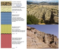
Figure 2. a. A simplified stratigraphic column of the study area. Descriptions are given next to the column together with deformational phases and unconformities. Modified after van Gorp et al., 2013; Maddy et al., 2012; Ersoy et al., 2010. b. (right) Outcrop expressions of intensive erosion processes with; A general view of the area (upper right), and example of hoodoos (fairy chimney) (lower right) exposed in numerous places in the study area.
Objectives
We propose a multidisciplinary approach, which is meant to become a benchmark for four-dimensional framework in badlands research. To be able to analyse the intensive erosional processes that lead to the development of badlands, the change in landscape should be examined with high resolution geochronology with links to:
i)climate change,
ii)land use and management,
iii)local geology and tectonics.
Research Methodology
• Geological mapping/ Facies analysis
• Geochronological dating
• Digital elevation model construction using UAV/drone aerial photography
• Dynamic landscape modelling
References
- Bozkurt, E., 2001. Neotectonics of Turkey – a synthesis. Geodinamica Acta 14, 3–30. doi:10.1016/S0985-3111(01)01066-X
- Çiftçi, N.B., Bozkurt, E., 2009. Pattern of normal faulting in the Gediz Graben, SW Turkey. Tectonophysics 473, 234–260. doi:10.1016/j.tecto.2008.05.036
- Ersoy, Y.E., Helvaci, C., Sözbilir, H., 2010. Tectono-stratigraphic evolution of the NE-SW-trending superimposed Selendi basin: Implications for late Cenozoic crustal extension in Western Anatolia, Turkey. Tectonophysics 488, 210–232. doi:10.1016/j.tecto.2010.01.007
- Jain, M., Buylaert, J.P., Thomsen, K.J., Murray, A.S., 2015. Further investigations on “non-fading” in K-Feldspar. Quaternary International 362, 3–7. doi:10.1016/j.quaint.2014.11.018
- Le Pichon, X., Kreemer, C., 2010. The Miocene-to-Present Kinematic Evolution of the Eastern Mediterranean and Middle East and Its Implications for Dynamics. Annual Review of Earth and Planetary Sciences 38, 323–351. doi:10.1146/annurev-earth-040809-152419
- Maddy, D., Demir, T., Bridgland, D.R., Veldkamp, A., Stemerdink, C., van der Schriek, T., Westaway, R., Schriek, T. Van Der, Westaway, R., van der Schriek, T., Westaway, R., 2008. The Early Pleistocene development of the Gediz River, Western Turkey: An uplift-driven, climate-controlled system? Quaternary International 189, 115–128. doi:10.1016/j.quaint.2007.08.045
- Maddy, D., Demir, T., Veldkamp, A., Bridgland, D.R., Stemerdink, C., Van Der schriek, T., Schreve, D., 2012. The obliquity-controlled early Pleistocene terrace sequence of the Gediz River, western Turkey: a revised correlation and chronology. Journal of the Geological Society 169, 67–82. doi:10.1144/0016-76492011-011
- Maddy, D., Schreve, D., Demir, T., Veldkamp, A., Wijbrans, J.R., van Gorp, W., van Hinsbergen, D.J.J., Dekkers, M.J., Scaife, R., Schoorl, J.M., Stemerdink, C., van der Schriek, T., 2015. The earliest securely-dated hominin artefact in Anatolia? Quaternary Science Reviews 109, 68–75. doi:10.1016/j.quascirev.2014.11.021
- Şengör, A.M.C., Bozkurt, E., 2013. Layer-parallel shortening and related structures in zones undergoing active regional horizontal extension. International Journal of Earth Sciences 102, 101–119. doi:10.1007/s00531-012-0777-0
- Şengör, A.M.C., Tüysüz, O., İmren, C., Sakınç, M., Eyidoğan, H., Görür, N., Le Pichon, X., Rangin, C., 2005. The North Anatolian Fault: a new look. Annual Review of Earth and Planetary Sciences 33, 37–112. doi:10.1146/annurev.earth.32.101802.120415
- Tokçaer, M., Agostini, S., Savaşçin, M.Y., 2005. Geotectonic setting and origin of the youngest Kula volcanics (western Anatolia), with a new emplacement model. Turkish Journal of Earth Sciences 14, 145–166.
- van Gorp, W., Schoorl, J.M., Temme, A.J.A.M., Reimann, T., Wijbrans, J.R., Maddy, D., Demir, T., Veldkamp, T., 2016. Catchment response to lava damming: integrating field observation, geochronology and landscape evolution modelling. Earth Surface Processes and Landforms 41, 1629–1644. doi:10.1002/esp.3981
- van Gorp, W., Temme, A.J.A.M., Baartman, J.E.M., Schoorl, J.M., 2014. Landscape evolution modelling of naturally dammed rivers. Earth Surface Processes and Landforms 39, 1587–1600. doi:10.1002/esp.3547
- van Gorp, W., Temme, A.J.A.M., Veldkamp, A., Schoorl, J.M., 2015. Modelling long-term (300ka) upland catchment response to multiple lava damming events. Earth Surface Processes and Landforms 40, 888–900. doi:10.1002/esp.3689
- van Gorp, W., Veldkamp, A., Temme, A.J.A.M., Maddy, D., Demir, T., van der Schriek, T., Reimann, T., Wallinga, J., Wijbrans, J., Schoorl, J.M., 2013. Fluvial response to Holocene volcanic damming and breaching in the Gediz and Geren rivers, western Turkey. Geomorphology 201, 430–448. doi:10.1016/j.geomorph.2013.07.016
- Westaway, R., Pringle, M., Yurtmen, S., Demir, T., Bridgland, D., Rowbotham, G., Maddy, D., 2004. Pliocene and Quaternary regional uplift in western Turkey: The Gediz River terrace staircase and the volcanism at Kula, Tectonophysics. doi:10.1016/j.tecto.2004.07.01
- Media appearance, 2017. Badlands project, Kula, western Turkey. URL https://www.wur.nl/en/Expertise-Services/Chair-groups/Environmental-Sciences/Soil-Geography-and-Landscape-Group/News/Show/Badlands-and-FACSIMILE-projects-hit-the-local-news.htm