
Nieuws
Spatial Accuracy Assessment and Integration of Global Land Cover Datasets
The article of Nandin-Erdene Tsendbazar, Sytze de Bruin, Steffen Fritz and Martin Herold: Spatial Accuracy Assessment and Integration of Global Land Cover Datasets, has been published in Remote Sensing, 2015, 7(12), 15804-15821.
Abstract
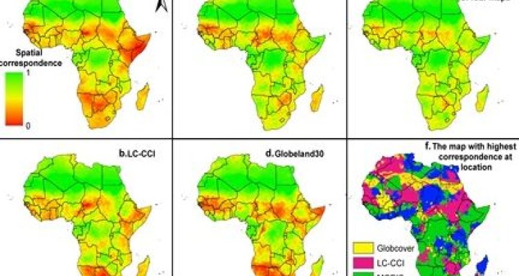
Along with the creation of new maps, current efforts for improving global land cover (GLC) maps focus on integrating maps by accounting for their relative merits, e.g., agreement amongst maps or map accuracy. Such integration efforts may benefit from the use of multiple GLC reference datasets. Using available reference datasets, this study assesses spatial accuracy of recent GLC maps and compares methods for creating an improved land cover (LC) map. Spatial correspondence with reference dataset was modeled for Globcover-2009, Land Cover-CCI-2010, MODIS-2010 and Globeland30 maps for Africa. Using different scenarios concerning the used input data, five integration methods for an improved LC map were tested and cross-validated. Comparison of the spatial correspondences showed that the preferences for GLC maps varied spatially. Integration methods using both the GLC maps and reference data at their locations resulted in 4.5%–13% higher correspondence with the reference LC than any of the input GLC maps. An integrated LC map and LC class probability maps were computed using regression kriging, which produced the highest correspondence (76%). Our results demonstrate the added value of using reference datasets and geostatistics for improving GLC maps. This approach is useful as more GLC reference datasets are becoming publicly available and their reuse is being encouraged.
Keywords: global land cover; data integration; spatial accuracy; geostatistics; reference dataset