
Thesis subject
Msc thesis topic: Global earth observation products: are they useful for countries?
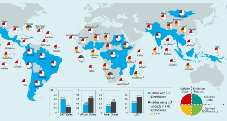
Accurate monitoring of forest, land use and land cover at the national level has become essential for the successful implementation and evaluation of policies related to climate, environment and agriculture, such as UNFCCC-NDC, UN-SDG, and European Green Deal. However, for many countries developing reliable monitoring systems can be challenging, especially due to limitations in technical and financial resources.
At the same time, open satellite data acquisition and processing advancements have led to many advanced global products on forest, land use and land cover such as Global Forest Change and Global Land Analysis & Discovery (GLAD). These products target globally consistent monitoring. But they can also assist countries with limited monitoring capabilities as they offer spatially detailed information with a resolution of 10-30 meters. However, a question remains if they are used to their potential and if not what information is required for map users for their uptake of global datasets.
This research aims to review the national and regional use of global datasets and identify gaps in improving the uptake of advanced global datasets.
Overall aim
- To review the national or regional use of global open data
- To implement country-specific comparison of global open data
- To identify gaps in assessing the quality of global open data
Literature
- Hansen, M. C. et al. High-Resolution Global Maps of 21st-Century Forest Cover Change. Science 342, 850-853, doi:10.1126/science.1244693 (2013).
- Melo, J., Baker, T., Nemitz, D., Quegan, S. & Ziv, G. Satellite-based global maps are rarely used in forest reference levels submitted to the UNFCCC. Environmental Research Letters 18, 034021, doi:10.1088/1748-9326/acba31 (2023).
- Carter, S. & Herold, M. Specifications of land cover datasets for SDG indicator monitoring. (2019).
Requirements
- Geotools
- Interests to work in Google Earth Engine
Theme(s): Integrated Land Monitoring