
Project
Climate-Smart Fertilizer Recommendations for Ethiopia
Ethiopia's rainfed-dependent agriculture faces climate change challenges. Current fertilizer practices lack spatial consideration, impacting soil and crop diversity. This PhD research aims to enhance climate-smart fertilizer recommendations in central Ethiopia. By analyzing legacy datasets, the project maps soil properties, validates root zone water capacity, models crop responses to nutrients, and derives climate-smart fertilizer recommendations for wheat and maize. Results will guide more adaptive agricultural practices in response to changing climate conditions.
Ethiopia’s agricultural sector employs 70% of its population and is a major contributor to export earnings with over 85% of total exports (Eshete Getachew et al., 2020). It constitutes 41.7% of the gross domestic product (Komarek et al., 2019) of which maize and wheat, for example, together account for 5.5% of the gross domestic product, and 14.9% of household consumption. The sector is largely formed by small-scale farms with average farm sizes ranging from 0.5–2 ha, that account for 96% of the total cultivated area (FAO, 2016). Cultivation is mainly rainfed-dependent and the area has been facing increasingly unpredictable rains and, in some years, a complete lack of seasonal rains as a result of climate change (CCP, 2018). To achieve and maintain food security for the growing population of the country (2.6% annual growth, Yalew et al., 2018; Eshete Getachew et al., 2020), climate-smart agriculture is indispensable. It should focus on a sustainable increase in agricultural productivity while building resilience and adaptive capacity (CIAT, 2017; FAO, 2021). Furthermore, crop production in the country needs to use inputs like inorganic fertilizers in a more efficient way (Komarek et al., 2019) to make agriculture more productive and sustainable as well as profitable. The efficiency of fertilizers however is much impacted by the variation, and change, in climate.
In Ethiopia, the use of inorganic fertilizers (urea and di-ammonium phosphate for N and P sources) started in the 1970s and resulted in a substantial yield and production increase (Erkossa et al., 2022). The corresponding fertilizer recommendations though were mostly blanket, regardless of the spatial variability of climate, soil and crop type. The development of soil test crop response-based fertilizer recommendations was a major focus of research from 2000 to 2015 and resulted in the development of critical soil P values (thresholds), and fertilizer P requirements for major crops across soil types in the country (Desalegn et al., 2019; Erkossa et al., 2022). However, the soil test-based approach was not adopted by farmers due to the cost of sample collection and laboratory testing being beyond the resource-poor smallholder farmers’ investment capacity (Tamene et al., 2017). Since 2014, compounded fertilizers blending N and P with K, S, B and Zn, were introduced. The compounded fertilizers were developed based on soil maps for 22 different soil properties (mainly nutrients), which were produced by digital soil mapping using the data from tens of thousands of topsoil samples collected from the entire country through the Ethiopian Soil Information Service (EthioSIS). However, the development of these recommendations was without proper crop response data and validation. This has been criticized by many national and international scientists (Erkossa et al., 2022) claiming that the identification of nutrient contents in the soil is not enough to develop reliable fertilizer recommendations. Various environmental conditions should be considered, e.g., by using models and digital applications, to estimate the crop nutrient requirements or demand as suggested by Schut & Giller (2020), rather than relying solely on a single soil test. Recently, Abera et al. (2022) established a machine learning model to develop a site-specific fertilizer recommendation for wheat (Triticum aestivum) employing a large training dataset of 6585 wheat field trials. They used a data mining approach considering site characteristics such as climate variables (temperature, rainfall, and solar radiation); soil factors (soil organic carbon, moisture, pH, texture, cation exchange capacity, and level of macro and micronutrients); and topographic position indices. However, they considered only the top soil properties but not the rootable soil depth and the associated plant available water holding capacity. In addition, machine learning methods cannot easily be extrapolated beyond the feature space comprised by the training data (Meyer & Pebesma, 2021), which makes it difficult to give spatial fertilizer recommendation and run climate change scenarios.
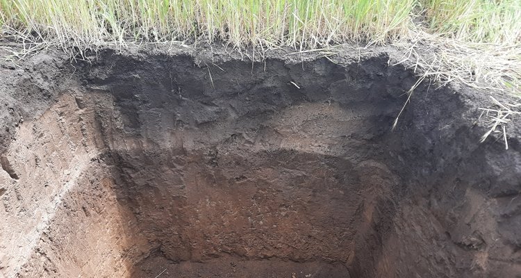
For rainfed crop production areas, understanding the spatial distribution of the soil's root zone water-holding capacity is necessary for estimating the water-limited yield (Yw) potential of crops using the World Food Studies (WOFOST) crop simulation model (de Wit et al., 2019), which is needed for developing climate-smart fertilizer recommendations. The Yw depends on the soil water availability as determined by amounts of rainfall and evapotranspiration, and their distribution over the growing season, by soil type, soil depth and groundwater influence (de Wit et al., 2019; de Wit & Boogaard, 2021). Moreover, the soil water availability during the growth period is determined by the rootable soil depth, defined as the soil depth that can be effectively explored by the crop root system to absorb water and nutrients without severe physical or chemical constraints to root growth or functionality. It is the most important soil factor for estimating the Yw under rainfed conditions (Grassini et al., 2015; Leenaars et al., 2018a). However, it was not much studied (Leenaars et al., 2018a). The soil water availability used for WOFOST simulations is often only a rough estimate, even though the sensitivity of Yw to the initial soil water availability is often quite strong (de Wit & Boogaard, 2021).
Yw could be used as a reference for defining management-dependent, attainable yield to determine the crop demand for nutrients (nitrogen, phosphorus and potassium) using the Quantitative Evaluation of the Fertility of Tropical Soils (QUEFTS) model. This model has been used for developing fertilizer recommendations (Smaling & Janssen, 1993; Sattari et al., 2014; Ravensbergen et al., 2021) based on a predefined yield potential, with other growth conditions considered optimal, including well drained and deep soil (Janssen et al., 1990). The model calculates the soil supply of available nutrients from the topsoil chemical characteristics (soil pH, soil organic carbon (SOC), available P (Olsen P) and exchangeable K), assuming that the availability and uptake of nutrients are the only factors limiting crop yield. However, the predefined yield potential used in QUEFTS should account for different agroclimatic conditions, water supply and sub-soil properties, such as rootable soil depth and the soil water-holding capacity (Sattari et al., 2014; Pushpalatha & Byju, 2022). Moreover, as the yield potential of crops is likely to vary from place to place, the use of covariate layers containing information on e.g., rooting depth and water availability may help to adjust the predefined yield potential to local conditions, thereby improving the accuracy of QUEFTS predictions (Leenaars et al., 2018b; Breure et al., 2022). Hence, combining WOFOST and QUEFTS allows to estimate crop response to fertilizer nutrients and to derive site-specific fertilizer recommendations (Leenaars et al., 2018b).
Current state-of-the-art technologies like digital soil mapping have been successfully used to produce maps with input data for models (Leenaars et al., 2018b; Breure et al., 2022) and driving site-specific fertilizer recommendations at scale. Such models require accurate and accessible land, soil and crop data. In Ethiopia, soil and fertilizer response data have been collected over the past sixty years. But these data are often not used effectively to inform decision-making, for example for site-specific fertilizer recommendations, because they are not available in an organized and accessible form. In 2018, a Coalition of the Willing (CoW) started bringing together individuals and institutions from Ethiopia that are willing to share and facilitate access to soil and agronomy data. It created an opportunity to bring data together (> 14K harmonized soil profile data and several crop responses to fertilizers trial data) in a central database (Ali et al., 2020). In this research, the legacy soil profile data collated by the CoW (>1,300 locations) and relatively recent high-density topsoil data from EthioSIS (>13,000 locations), along with up-to-date and fine-resolution environmental covariates will be used and are expected to prove very useful to achieve the objectives of this PhD-research.
Objectives
The overall objective of this research is to generate quality-assessed soil and crop information and use this information to support the development of climate-smart site-specific fertilizer recommendations in central Ethiopia. The research has the following four specific objectives:
- Map primary soil properties of central Ethiopia at 100 m resolution;
- Map the soil’s root zone depth (RZD) and the root zone plant-available water-holding capacity (RZ-PAWHC) for maize and wheat in the study area and validate these maps with independent measurements of these complex soil properties;
- Model crop yield response to soil and fertilizer nutrients in central Ethiopia using WOFOST and QUEFTS;
- Derive maps of climate-smart and farmer-relevant fertilizer recommendations for wheat and maize. Each specific objective will be a separate chapter in the PhD-thesis and published in the peer review scientific literature.
Hypotheses
The research hypotheses for all four objectives are as follows:
- Objective 1: The use of dense soil properties data, including legacy soil profile data (~2800) and topsoil data (~11,000), will result in a significant improvement in the accuracy of soil property mapping compared to the Africa SoilGrids map.
- Objective 2: The validated root zone plant available water holding capacity (RZ-PAWHC) map of the study area will exhibit more than 20% increase in accuracy (i.e., reduction in RMSE) compared to the continental map.
- Objective 3: Fertilizer recommendations based on WOFOST and QUEFTS differ significantly from recommendations provided by machine learning algorithms and are less sensitive to training data sample size.
- Objective 4: The impact of future climate change on crop production and fertilizer recommendation will be greater for shallow than for deep soils.