Impact story
Coastal city waterfront adaptation to combat sea-level rise
Coastal cities are attractive, as they offer a more moderate climate, diverse natural ecosystems, access to water for commerce (ports) and recreation and an entryway to the hinterland, through rivers that connect with oceans. As many coastal cities are in low-lying areas and prone to land subsidence, they are vulnerable to coastal flooding and will only become more vulnerable in the face of rising sea-levels and more frequent storms. Cities, therefore, need to adapt themselves to these changes.
Motivation
San Francisco (USA) is a City that is vulnerable to the impacts of sea-level rise. Where neighbourhood redevelopment is now occurring, there were once wetlands and tidal basins, 100 years ago. Over the decades, developable lands were created by infill that resulted in a low-lying district that needs a long-term sea-level rise strategy. San Francisco begins to understand the likelihood and impacts of high-water, and considers if those impacts are acceptable. One of the key questions for San Francisco in adaptation planning is where to put the line of defence – or in other words, what is allowed to flood and what is not. Will the new shoreline protection be along the shore, and will new infrastructure be built further out, or could some portions of the City be given back to the bay?
Solution
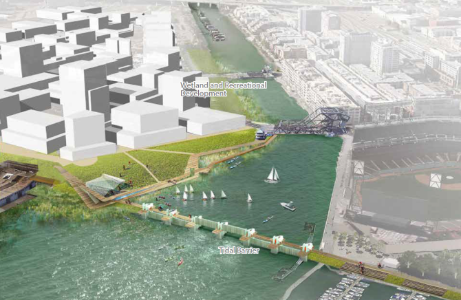
To imagine what its future might look like with sea-level rise, and to consider options to make the waterfront more resilient, multiple agencies from the City and County of San Francisco teamed up with the consortium in an iterative design process. Using Mission Creek and the Mission Bay shoreline as a test case, the team sought to consider ways the shoreline could be modified to provide resilience for a rapidly growing mixed-use neighbourhood. We developed different adaptation concepts, for the creek and the bay shoreline. As for the creek, a tidal barrier at the mouth of the creek that can be closed during high tides and storm surge can be constructed. As for the bay shoreline, a continuous landmass in the Bay outboard of the piers can be created, parallel to the existing shoreline, to be used for new commercial and residential development, recreation and habitat development. The profits from real estate development can (partly) cover the reconstruction expenses.
Wageningen University & Research carried out these activities in cooperation with: ARCADIS-US, SPUR and the San Francisco Bay Conservation and Development Commission.
The profits from real estate development can cover the reconstruction expenses
Impact and future perspective
This study is a first step in trying to imagine what a future with sea-level rise could look like for San Francisco. Developing technical engineering solutions is likely to be the easiest part; arranging funding, regulatory compliance, and community- and political support will be much more challenging.
