
MSc thesis topics: Integrated Land Monitoring
-
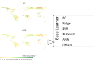
MSc thesis topic: Above-ground Biomass Change (ΔAGB) mapping using stacked machine learning models
A model-based approach to mapping ΔAGB in selected countries with in-situ data. -
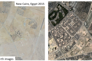
MSc thsis topic: AI for land cover change monitoring
Monitoring land cover change is essential for understanding and adapting to many challenges we are facing today from climate change to sustainable... -
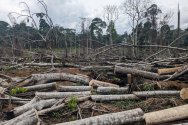
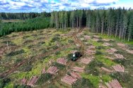
MSc thesis topic: Assessing patterns of tropical forest disturbances [using the RADD alerts]
The RADD (RAdar for Detecting Deforestation) alerts offer insights into tropical forest disturbances. Leveraging data from Sentinel-1, a SAR satellite... -

MSc thesis topic: Assessing spatial fairness of maps with deep learning
The quality of remote sensing based land monitoring is often varies across space. In data rich regions such as Europe and North America, the maps tend... -

MSc thesis topic: Automated change detection and classification at a large scale in BFAST Lite
BFAST Lite is a newly developed change detection algorithm based on the established foundation of BFAST (Breaks For Additive Season and Trend) family... -
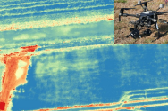
MSc thesis topic: Capturing drought stress resilience in grass with UAV thermal imaging
In light of changing climate drought resilience of grass used in urban parks and sport fields is becoming increasingly important for ensuring service... -

MSc thesis topic: Cashew Mapping across Continents with Location Information
Cashew mapping emerges as a critical endeavor, particularly in regions like Africa and Southeast Asia, where it stands as a vital cash crop cultivated... -

MSc thesis topic: Comparison of land cover change detection methods at a global scale
Land cover change monitoring is essential for sound policymaking and keeping track of what effects policies have over time. Automatic land cover... -

MSc thesis topic: Detecting reindeer carrion in the Arctic tundra of Svalbard
Dead organic matter comprises the basal trophic level of many food webs globally and promotes biodiversity and ecosystem stability. Dead organic... -
MSc thesis topic: Dutch Forest Monitor - AHN based forest change detection in the Netherlands
ALS | Airborne Lidar Scanning data (ALS) provides height information in XYZ points. ALS is commonly used to derive digital elevation models for larger...